River
Têt
116 km from source to mouth · France.
 FranceFlows into Mediterranean Sea
In numbers
Length
116km
Average flow
11m³/s
Basin
1,369km²
Drop
849m
from 849 m to 0 m
Country
1
The journey
From source to mouth
116 km of river and 57 stops on the way: 45 towns and cities on its banks, dams, bridges and the tributaries that feed it.
- 0 kmCarlitat 849 m
- 0 kmBolquère816 people
- 0 kmLes Angles597 people
- 0 kmLa Llagonne230 people
- 0 kmSauto102 people
- 0 kmPont Gisclard
- 0 kmLa Cabanasse713 people
- 0 kmSaint-Pierre-dels-Forcats260 people
- 0 kmPlanès57 people
- 0 kmMont-Louis153 people
- 1 kmFontpédrouse125 people
- 5 kmPont Séjourné
- 7 kmThuès-Entre-Valls25 people
- 11 kmCanaveilles53 people
- 13 kmNyer148 people
- 15 kmOlette360 people
- 16 kmSouanyas29 people
- 22 kmSerdinya236 people
- 25 kmFuilla435 people
- 26 kmRotjatributary
- 27 kmCorneilla-de-Conflent527 people
- 28 kmVillefranche-de-Conflent215 people
- 28 kmCadytributary
- 33 kmRia-Sirach1,264 people
- 34 kmCodalet350 people
- 37 kmPrades6,148 people
- 38 kmCatllar723 people
- 38 kmCastellanetributary
- 38 kmCaillantributary
- 43 kmEus386 people
- 46 kmMarquixanes599 people
- 46 kmArboussols130 people
- 49 kmLentillàtributary
- 51 kmVinça2,260 people
- 53 kmLac de Vinça0.6 km²
- 55 kmRodès758 people
- 56 kmPont aqueduc d'en Labau
- 57 kmBouleternère951 people
- 62 kmIlle-sur-Têt5,556 people
- 68 kmNéfiach1,383 people
- 74 kmMillas4,417 people
- 76 kmSaint-Féliu-d'Amont1,292 people
- 77 kmCorneilla-la-Rivière2,004 people
- 78 kmSaint-Féliu-d'Avall2,950 people
- 80 kmBoulèstributary
- 82 kmPézilla-la-Rivière4,129 people
- 85 kmLe Soler7,942 people
- 87 kmVilleneuve-la-Rivière1,360 people
- 89 kmBaho3,231 people
- 91 kmSaint-Estève11,630 people
- 95 kmPont ferroviari sobre la Tet
- 97 kmPerpignan121,616 people
- 102 kmBompas7,832 people
- 107 kmVillelongue-de-la-Salanque3,335 people
- 110 kmCanet-en-Roussillon13,227 people
- 112 kmSainte-Marie-la-Mer4,952 people
- 115 kmSainte-Marie-Plage3,927 people
- 116 kmBassetributary
- 116 kmMediterranean Seaat 0 m
Water level along the river (RiverATLAS; the height is exaggerated). Towns: GeoNames and Wikidata; bridges, dams and tributaries: Wikidata.
River in Roussillon, France
At the mouth it carries 11 m³/s on average: an Olympic pool every 227 seconds. It drops from 849 m to 0 m, 7.3 m per kilometre on average. Its basin covers 1,369 km², about the size of MQ. 188,000 people live in it. Highest water: from October to December; lowest: from July to August. Its dams hold back little of its water (3.7% of a year's flow).
Where to start
- PerpignanLargest city on its banks · 121,616 people
- Perpignan-Rivesaltes (Llabanère) Airport (PGF)Nearest airport with scheduled flights, 5 km from the cityCar hire at PGF airport (Perpignan/Rivesaltes)Discover Cars · Affiliate link↗
- On the water11 ferry piers, marinas, boat rentals and boat ramps along the river (OpenStreetMap)
- From May to SeptemberThe best months to visit
Têt, month by month
Highest water: from October to December
Lowest water: from July to August. Best months to visit: from May to September.
From about 6.1 m³/s in the lowest month to 38 m³/s in the highest. An estimate: the monthly flow is modelled from the lowest and highest months of WaterGAP (RiverATLAS, 1971–2000) and the rain and snow along the river (WorldClim). Dams change the real rhythm. The chip is the average air temperature; below it, the month's rain.
Plan the trip
Plan the trip: boat trips, a bed by the river, a car
Some links above are affiliate links: if you book through them we may earn a commission, at no extra cost to you. It never changes what the data on this page says.
The basin
Têt: the basin in numbers
1,400 km² of land send their water to this river. This is what lives on it.
- 188,000people live in the basin
- 134/km²people per km²
- 981maverage altitude of the basin
- 913mmof rain a year (basin average)
- 10.1°Caverage air temperature
- 50%protected areas
- 0.0km³held in reservoirs
What covers the basin
- 75% Forest
- 8% Cropland
- 6% Pasture
- 10% Towns and cities
RiverATLAS (HydroATLAS v1.0, CC BY 4.0): land cover, people, protected areas, glaciers and dams over the whole basin upstream of the mouth.
Along the river
Têt: what you find on the way
- 21Weirs
- 3WaterfallsSalt Gros
- 9Boat ramps
- 1MarinasPort nature de Saint-Marie de la Mer
- 5River beachesPlage publique des Escoumes, Plage du Roussillon, Plage de la jetée and 2 more
From OpenStreetMap, within 1.3 km of the river. Not mapped is not the same as not there.
Cross-checked with our atlases
Têt in our other atlases
What our sister atlases know about the waterfalls on this river, the lakes it flows through, the beaches at its mouth, the mountains where it rises and the islands off its mouth.
 1lake on its wayLakeyas
 7beaches at the mouth and on the banksCoastya
 126mountains at the sourcePeakyas
Lakes and reservoirs (1)
Lakes it flows through, by Lakeyas
- Lac de Vinçakm 400.6km²
Lakeyas is coming soonOpen Lakeyas ↗
Beaches (7)
At the mouth (25 km) and on the banks, by Coastya
- Torreilles Plage4.3 km away21.9°C
- Ansa de la Moresca23 km away · cove22.0°C
- Ansa Cristina23 km away · cove22.0°C
- Ansa Béar23 km away · cove22.0°C
- Anse de la Baleta22 km away · cove22.0°C
- Ansa Dels Reguers22 km away · cove22.0°C
- Ansa Santa Catarina24 km away · cove22.0°C
Mountains at the source (126)
Within 15 km of the source, by Peakyas
- Puigmal14 km away · prominence 1,331 m2,910m
- Bastiments10 km away · prominence 276 m2,881m
- Pic de Noufonts9.0 km away · prominence 210 m2,861m
- Pic del Segre13 km away · prominence 95 m2,843m
- Pic de l'Infern9.8 km away · prominence 164 m2,870m
- Pic de Finestrelles11 km away · prominence 221 m2,826m
- Pic d'Eina9.2 km away · prominence 57 m2,789m
- Pic de la Fossa del Gegant10 km away · prominence 84 m2,808m
118 more on PeakyasOpen Peakyas ↗
From space
The source and the mouth, seen from orbit
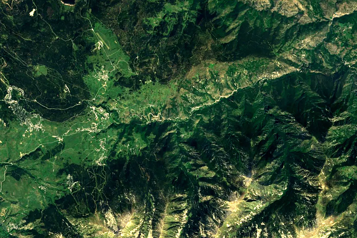
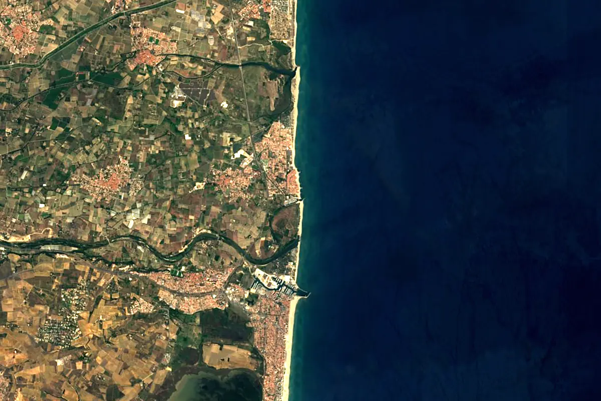
Sentinel-2 cloudless 2016 by EOX IT Services GmbH (contains modified Copernicus Sentinel data 2016), CC BY 4.0. The glowing line is the river as drawn by RiverATLAS.
Tributaries
Where it flows, and what flows into it
Tributaries (12)
Also: Basse, Cady, Castellane, Boulès, Lentillà, Caillan, Rotja, La Riberola, Ribera de Mentet, Ribera de Cabrils, Riberette, Lliterà
Nearby
Rivers nearby
 Spain
SpainWhere these numbers come from
| Name, length, places | Wikidata (Q1529011) · CC0 |
|---|---|
| Course, profile, basin | RiverATLAS v1.0 (HydroATLAS, Linke et al. 2019) · CC BY 4.0 — followed along the river network from the point given by Wikidata |
| Flow | WaterGAP (RiverATLAS), 1971–2000 · CC BY 4.0 |
| Climate along the river | WorldClim (RiverATLAS), 1970–2000 · CC BY 4.0 |
| Towns, bridges, dams | Wikidata · CC0; GeoNames · CC BY 4.0 |
| Along the river | © OpenStreetMap contributors · ODbL |
| Images | EOX Sentinel-2 cloudless 2016 · CC BY 4.0; Wikimedia Commons |
| Our other atlases | Lakeyas, Coastya, Peakyas — Wikidata · CC0; © OpenStreetMap contributors · ODbL; GeoNames · CC BY 4.0; HydroLAKES · CC BY 4.0; NOAA OISST |
Every source and licence is on the data sources page.
The family
Do you prefer beaches, lakes, mountains, waterfalls, islands, rivers or canyons?
Same idea, other landscapes: field atlases built on open data, month by month, in seven languages.
beaches Find your beach: sea temperature, sun and swimming month by month.Visit lakes
 Every lake on Earth: water temperature, ice, depth and the shore.Coming soonVisit mountains
 Every summit in 3D: summit weather, the 0 °C line, huts and trails.Visit
  waterfalls
 Every waterfall: height, flow month by month and when it roars.Coming soonVisit
  islands
 Every island from the sea up: size, sea temperature, ferries and 3D.Coming soonVisit
  rivers
 Every river from source to sea: the journey, the flow and the basin in numbers.You are here
 canyons
 Every canyon cut to scale: depth to the floor, rim and floor temperatures, trails and viewpoints.Coming soonVisit