River
Ob
3,650 km from source to mouth · Russia.
 RussiaFlows into Kara Sea3rd longest in Russia
In numbers
Length
3,650km
Average flow
12,500m³/s
Basin
2,990,000km²
Drop
339m
from 159 m to -180 m
Country
1
The journey
From source to mouth
3,650 km of river and 68 stops on the way: 4 towns and cities on its banks, dams, bridges and the tributaries that feed it.
- 0 kmKatunat 159 m
- 8 kmKatuntributary
- 8 kmBiyatributary
- 17 kmChemrovkatributary
- 19 kmPeschanayatributary
- 24 kmAnuytributary
- 96 kmCharyshtributary
- 137 kmBolshaya Rechkatributary
- 154 kmAleytributary
- 162 kmBolshaya Kalmankatributary
- 185 kmZalomnaya Protokatributary
- 219 kmLosikhatributary
- 219 kmBarnaulkatributary
- 221 kmRowing Canal0.6 km²
- 229 kmBarnaul632,372 people
- 234 kmBolshaya Cheremshankatributary
- 234 kmKislukhatributary
- 234 kmPovalikhatributary
- 250 kmSeredchikhatributary
- 265 kmKasmalatributary
- 273 kmChumyshtributary
- 312 kmInyatributary
- 321 kmShelabolikhatributary
- 343 kmMerettributary
- 352 kmVerkhniy Suzuntributary
- 352 kmSlezyankatributary
- 360 kmSuzuntributary
- 374 kmChirukhatributary
- 382 kmUstye Stepnayatributary
- 416 kmAllakskaya Suyevatributary
- 418 kmKamenskaya Suyevatributary
- 432 kmRazboynayatributary
- 506 kmOrdatributary
- 533 kmIrmentributary
- 535 kmKarakantributary
- 570 kmMiltyushtributary
- 585 kmEltsovkatributary
- 605 kmBol'shaya Tulatributary
- 608 kmKamenkatributary
- 608 kmNovosibirsk1,637,266 people
- 639 kmStaritsatributary
- 653 kmChaustributary
- 681 kmPorostributary
- 730 kmOyashtributary
- 730 kmTulatributary
- 741 kmKindatributary
- 748 kmIksatributary
- 778 kmUrtamkatributary
- 801 kmTagantributary
- 818 kmUskovkatributary
- 818 kmChichagtributary
- 828 kmYunzherkatributary
- 841 kmZharkovo0.6 km²
- 864 kmTomtributary
- 894 kmLobachyovatributary
- 912 kmAndrevatributary
- 932 kmShegarkatributary
- 949 kmBrovkatributary
- 979 kmVerkhnyaya Anmatributary
- 992 kmChulymtributary
- 1,006 kmKrivaya Lukatributary
- 1,006 kmTatoshtributary
- 1,041 kmKortatributary
- 1,046 kmIstok Karya Bolshayatributary
- 1,046 kmKaldzhatributary
- 1,046 kmSondrovkatributary
- 1,074 kmYagodnayatributary
- 1,722 kmNizhnevartovsk244,937 people
- 1,928 kmSurgut300,367 people
- 3,650 kmKara Seaat -180 m
Water level along the river (RiverATLAS; the height is exaggerated). Towns: GeoNames and Wikidata; bridges, dams and tributaries: Wikidata.
Second-longest river in Russia
At the mouth it carries 12,492 m³/s on average: 5.0 Olympic pools every second. It drops from 159 m to -180 m, 0.1 m per kilometre on average. Its basin covers 2,990,000 km², about the size of AR. 23.6 million people live in it. Highest water, with the snowmelt: from May to August; lowest: from January to April. Dams and reservoirs hold back a large share of its water (15% of a year's flow).
Where to start
- NovosibirskLargest city on its banks · 1,637,266 people
- Novosibirsk Tolmachevo Airport (OVB)Nearest airport with scheduled flights, 19 km from the city
- On the water168 ferry piers, marinas, boat rentals and boat ramps along the river (OpenStreetMap)
- From June to AugustThe best months to visit
Ob, month by month
Highest water: from May to August
Lowest water: from January to April. Freezing months (average below −4 °C): from November to March. Melting snow makes up much of its water. Best months to visit: from June to August.
From about 7,600 m³/s in the lowest month to 24,000 m³/s in the highest. An estimate: the monthly flow is modelled from the lowest and highest months of WaterGAP (RiverATLAS, 1971–2000) and the rain and snow along the river (WorldClim). Dams change the real rhythm. The chip is the average air temperature; below it, the month's rain.
Plan the trip
Plan the trip: boat trips, a bed by the river, a car
Some links above are affiliate links: if you book through them we may earn a commission, at no extra cost to you. It never changes what the data on this page says.
The basin
Ob: the basin in numbers
2,467,589 km² of land send their water to this river. This is what lives on it.
- 23.6millionpeople live in the basin
- 10/km²people per km²
- 291maverage altitude of the basin
- 465mmof rain a year (basin average)
- -0.5°Caverage air temperature
- 8%protected areas
- 1.9%covered by lakes
- 11%permafrost
- 64km³held in reservoirs
What covers the basin
- 47% Forest
- 11% Cropland
- 15% Pasture
RiverATLAS (HydroATLAS v1.0, CC BY 4.0): land cover, people, protected areas, glaciers and dams over the whole basin upstream of the mouth.
Along the river
Ob: what you find on the way
- 4Weirs
- 10Locks
- 2Waterfalls
- 11Boat ramps
- 113Ferry piers
- 41Marinas
- 7River beaches
From OpenStreetMap, within 3.2 km of the river. Not mapped is not the same as not there.
Cross-checked with our atlases
Ob in our other atlases
What our sister atlases know about the waterfalls on this river, the lakes it flows through, the beaches at its mouth, the mountains where it rises and the islands off its mouth.
 2lakes on its wayLakeyas
 2mountains at the sourcePeakyas
Lakes and reservoirs (2)
Lakes it flows through, by Lakeyas
- Rowing Canalkm 228 · 16 m deep0.6km²
- Zharkovokm 8680.6km²
Lakeyas is coming soonOpen Lakeyas ↗
Mountains at the source (2)
Within 15 km of the source, by Peakyas
- Uval Bol'shoy7.7 km away
- Uval Smolenskiy14 km away
From space
The source and the mouth, seen from orbit
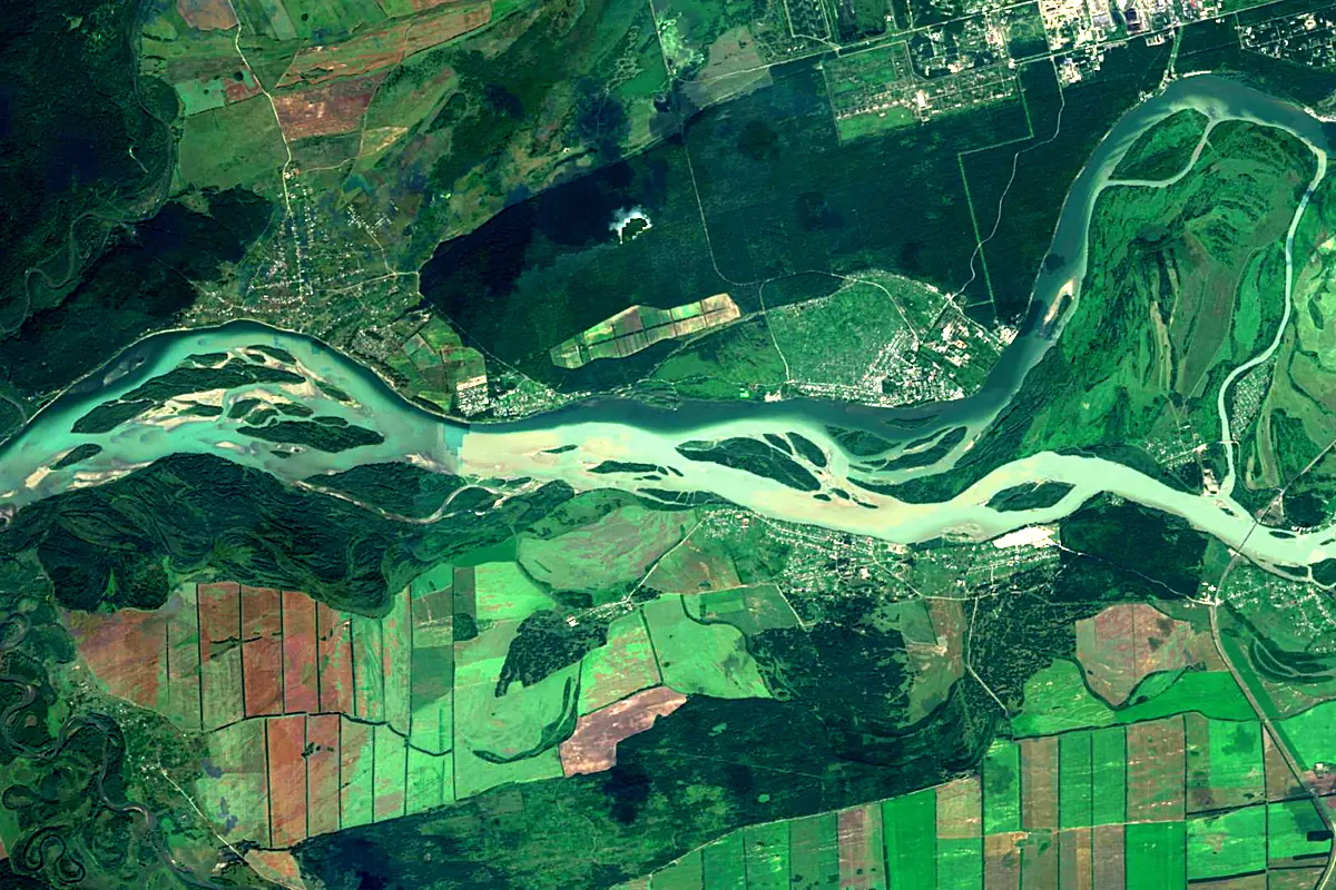
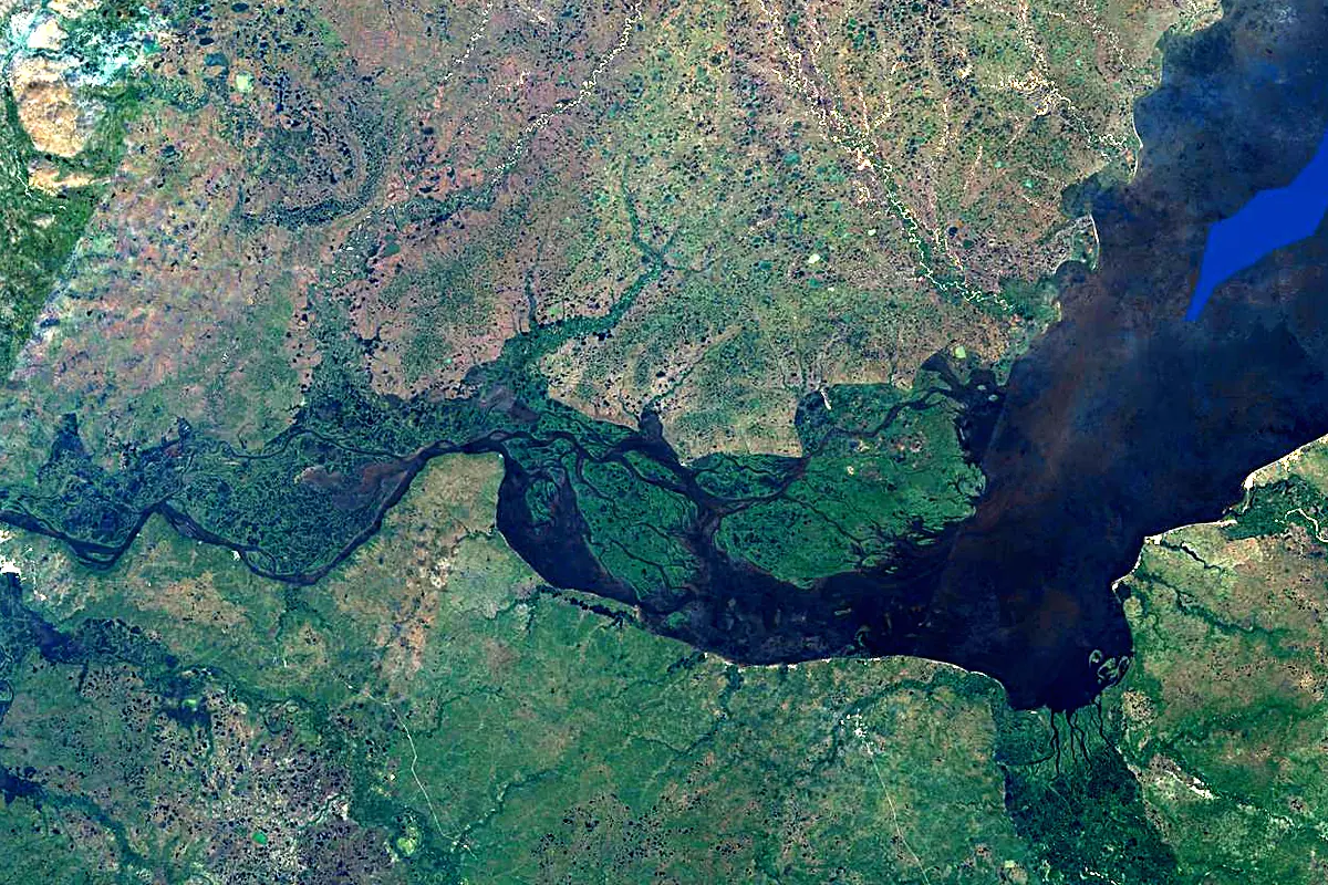
Sentinel-2 cloudless 2016 by EOX IT Services GmbH (contains modified Copernicus Sentinel data 2016), CC BY 4.0. The glowing line is the river as drawn by RiverATLAS.
Tributaries
Where it flows, and what flows into it
Tributaries (228)
Russia4,248 km3,000 m³/sjoins at km 2,280ChulymRussia1,799 km780 m³/sjoins at km 1,023KetRussia1,621 km560 m³/sjoins at km 1,300VasyuganRussia1,082 km330 m³/sjoins at km 1,367TomRussia827 km1,100 m³/sjoins at km 891KatunRussia688 km630 m³/sjoins at km 8BiyaRussia301 km480 m³/sjoins at km 8Also: Aley, Bolshoy Yugan, Vakh, Severnaya Sosva, Charysh, Tym, Anuy, Inya, Chumysh, Kazym, Tromyogan, Parabel, Chaya, Bolshoy Salym, Vatinsky Egan, Lyamin, Pim River, Poluy, Kievsky Yogan, Barnaulka, Shegarka, Nazym, Peschanaya, Kasmala
 Kazakhstan
Nearby
Rivers nearby
Where these numbers come from
| Name, length, places | Wikidata (Q973) · CC0 |
|---|---|
| Course, profile, basin | RiverATLAS v1.0 (HydroATLAS, Linke et al. 2019) · CC BY 4.0 — followed from the source to the mouth given by Wikidata |
| Flow | WaterGAP (RiverATLAS), 1971–2000 · CC BY 4.0 |
| Climate along the river | WorldClim (RiverATLAS), 1970–2000 · CC BY 4.0 |
| Towns, bridges, dams | Wikidata · CC0; GeoNames · CC BY 4.0 |
| Along the river | © OpenStreetMap contributors · ODbL |
| Images | EOX Sentinel-2 cloudless 2016 · CC BY 4.0; Wikimedia Commons |
| Our other atlases | Lakeyas, Peakyas — Wikidata · CC0; © OpenStreetMap contributors · ODbL; GeoNames · CC BY 4.0; HydroLAKES · CC BY 4.0; NOAA OISST |
Every source and licence is on the data sources page.
The family
Do you prefer beaches, lakes, mountains, waterfalls, islands, rivers or canyons?
Same idea, other landscapes: field atlases built on open data, month by month, in seven languages.
 beaches
 Find your beach: sea temperature, sun and swimming month by month.Visit lakes
 Every lake on Earth: water temperature, ice, depth and the shore.Coming soonVisit mountains
 Every summit in 3D: summit weather, the 0 °C line, huts and trails.Visit
  waterfalls
 Every waterfall: height, flow month by month and when it roars.Coming soonVisit
  islands
 Every island from the sea up: size, sea temperature, ferries and 3D.Coming soonVisit
  rivers
 Every river from source to sea: the journey, the flow and the basin in numbers.You are here
 canyons
 Every canyon cut to scale: depth to the floor, rim and floor temperatures, trails and viewpoints.Coming soonVisit