River
Snake River
1,735 km from source to mouth · United States.
 United StatesFlows into Columbia River7th longest in United States
In numbers
Length
1,735km
Average flow
1,600m³/s
Basin
278,450km²
Drop
2,225m
from 2,327 m to 102 m
Country
1
The journey
From source to mouth
1,735 km of river and 68 stops on the way: 11 towns and cities on its banks, dams, bridges and the tributaries that feed it.
- 0 kmYellowstone National Parkat 2,327 m
- 38 kmLewis Rivertributary
- 38 kmMoose Falls
- 83 kmJackson Lake106 km²
- 85 kmEmma Matilda Lake3.5 km²
- 119 kmMenor's Ferry
- 124 kmPhelps Lake1.8 km²
- 134 kmGros Ventre Rivertributary
- 204 kmAlpine1,220 people
- 208 kmGreys Rivertributary
- 208 kmSalt Rivertributary
- 231 kmPalisades Reservoir60 km²
- 232 kmPalisades Dam
- 301 kmRirie A Pegram Truss Railroad Bridge
- 329 kmHenrys Forktributary
- 342 kmRoberts Slough0.6 km²
- 372 kmIdaho Falls64,818 people
- 421 kmBlackfoot11,740 people
- 436 kmBlackfoot Rivertributary
- 455 kmFort Hall
- 467 kmPortneuf Rivertributary
- 477 kmBannock Creektributary
- 493 kmAmerican Falls Reservoir199 km²
- 493 kmAmerican Falls
- 533 kmRaft Rivertributary
- 555 kmLake Walcott31 km²
- 594 kmBurley10,436 people
- 594 kmGoose Creektributary
- 624 kmCaldron Linn
- 641 kmHansen Bridge (1966)
- 651 kmShoshone Falls65 m
- 654 kmPillar Falls
- 655 kmPerrine Bridge
- 657 kmTwin Falls51,807 people
- 695 kmSalmon Falls Creektributary
- 703 kmUpper Salmon Falls
- 716 kmLower Salmon Falls
- 717 kmThousand Springs State Park
- 722 kmMalad Rivertributary
- 839 kmBruneau Rivertributary
- 840 kmC. J. Strike Reservoir25 km²
- 914 kmGuffey Butte–Black Butte Archaeological District
- 968 kmHomedale2,881 people
- 1,003 kmFort Boise
- 1,004 kmOwyhee Rivertributary
- 1,004 kmBoise Rivertributary
- 1,011 kmNyssa3,198 people
- 1,031 kmFruitland6,072 people
- 1,034 kmOntario10,999 people
- 1,038 kmMalheur Rivertributary
- 1,043 kmPayette8,127 people
- 1,047 kmPayette Rivertributary
- 1,065 kmWeiser Rivertributary
- 1,102 kmBurnt Rivertributary
- 1,150 kmPowder Rivertributary
- 1,183 kmOxbow Reservoir4.5 km²
- 1,274 kmHells Canyon Archaeological District
- 1,309 kmImnaha Rivertributary
- 1,314 kmSalmon Rivertributary
- 1,345 kmGrande Ronde Rivertributary
- 1,389 kmLewiston34,203 people
- 1,391 kmClearwater Rivertributary
- 1,439 kmLower Granite Dam
- 1,497 kmLittle Goose Dam
- 1,509 kmTucannon Rivertributary
- 1,514 kmSnake River Bridge
- 1,514 kmPalouse Rivertributary
- 1,543 kmLower Monumental Dam
- 1,592 kmIce Harbor Dam
- 1,735 kmColumbia Riverat 102 m
Water level along the river (RiverATLAS; the height is exaggerated). Towns: GeoNames and Wikidata; bridges, dams and tributaries: Wikidata.
Major tributary of the Columbia River in the northwestern United States
At the mouth it carries 1,550 m³/s on average: an Olympic pool every 1.6 seconds. It drops from 2,327 m to 102 m, 1.3 m per kilometre on average. Its basin covers 278,450 km², about the size of BF. 3.9 million people live in it. Highest water, with the snowmelt: from March to June; lowest: February and from August to October. It is heavily dammed: reservoirs can hold 52% of a year's flow.
Where to start
- Idaho FallsLargest city on its banks · 64,818 people
- Idaho Falls Regional Airport (IDA)Nearest airport with scheduled flights, 4 km from the cityCar hire at IDA airport (Idaho Falls)Discover Cars · Affiliate link↗
- On the water186 ferry piers, marinas, boat rentals and boat ramps along the river (OpenStreetMap)
- Kayak and canoe105 put-ins and rapids mapped (OpenStreetMap)
- From June to SeptemberThe best months to visit
Snake River, month by month
Highest water: from March to June
Lowest water: February and from August to October. Melting snow makes up much of its water. Best months to visit: from June to September.
From about 1,700 m³/s in the lowest month to 12,000 m³/s in the highest. An estimate: the monthly flow is modelled from the lowest and highest months of WaterGAP (RiverATLAS, 1971–2000) and the rain and snow along the river (WorldClim). Dams change the real rhythm. The chip is the average air temperature; below it, the month's rain.
Plan the trip
Plan the trip: boat trips, a bed by the river, a car
Some links above are affiliate links: if you book through them we may earn a commission, at no extra cost to you. It never changes what the data on this page says.
The basin
Snake River: the basin in numbers
530,572 km² of land send their water to this river. This is what lives on it.
- 3.9millionpeople live in the basin
- 8/km²people per km²
- 1,423maverage altitude of the basin
- 538mmof rain a year (basin average)
- 4.7°Caverage air temperature
- 12%protected areas
- 1.2%covered by lakes
- 2%permafrost
- 87km³held in reservoirs
What covers the basin
- 56% Forest
- 10% Cropland
- 26% Pasture
RiverATLAS (HydroATLAS v1.0, CC BY 4.0): land cover, people, protected areas, glaciers and dams over the whole basin upstream of the mouth.
Along the river
Snake River: what you find on the way
- 156WeirsIdaho Diversion Dam, Upper Idaho Falls Number Two Dam, Idaho Falls and 153 more
- 13LocksSnake River, Little Goose Lock and Dam, Lower Monumental Lock and Dam and 10 more
- 21WaterfallsMoose Falls, Fall Creek Falls, Idaho Falls and 18 more
- 105RapidsBig Kahuna, Lunch Counter, Caldron Linn and 102 more
- 179Boat rampsPacific Creek Landing, Moose Landing, Wilson Boat Ramp and 176 more
- 2Ferry piers
- 4MarinasLeeks Marina, Colter Bay Marina, Hells Gate Marina and 1 more
- 4River beachesPalisades Bench, Bronco Beach, Red Ledge and 1 more
From OpenStreetMap, within 2.8 km of the river. Not mapped is not the same as not there.
Cross-checked with our atlases
Snake River in our other atlases
What our sister atlases know about the waterfalls on this river, the lakes it flows through, the beaches at its mouth, the mountains where it rises and the islands off its mouth.
 8waterfalls on the riverCascadyas
 9lakes on its wayLakeyas
 4mountains at the sourcePeakyas
Waterfalls (8)
On the river, by Cascadyas
- Moose Fallskm 37
- American Fallskm 480
- Caldron Linnkm 608
- Twin Fallskm 630
- Shoshone Fallskm 63465m
- Pillar Fallskm 636
- Upper Salmon Fallskm 685
- Lower Salmon Fallskm 697
Cascadyas is coming soonOpen Cascadyas ↗
Lakes and reservoirs (9)
Lakes it flows through, by Lakeyas
- Jackson Lakekm 81 · 134 m deep106km²
- Emma Matilda Lakekm 833.5km²
- Phelps Lakekm 1211.8km²
- Palisades Reservoirkm 22560km²
- American Falls Reservoirkm 480199km²
- Lake Walcottkm 54131km²
- C. J. Strike Reservoirkm 81825km²
- Oxbow Reservoirkm 1,1524.5km²
1 more on LakeyasLakeyas is coming soonOpen Lakeyas ↗
Mountains at the source (4)
Within 15 km of the source, by Peakyas
- Barlow Peak14 km away2,929m
- Gravel Peak14 km away
- Hawks Rest11 km away
- Yellowstone Point13 km away
From space
The source and the mouth, seen from orbit
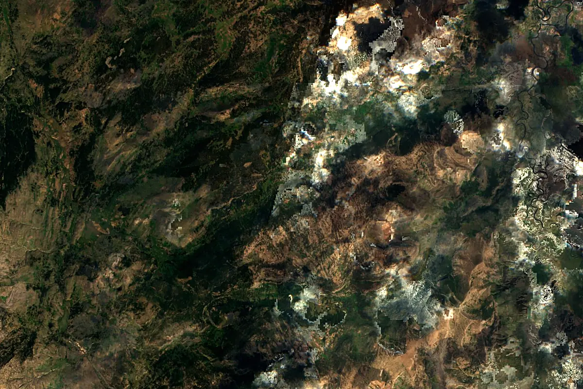
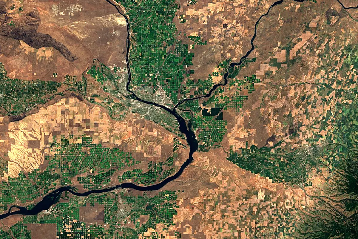
Sentinel-2 cloudless 2016 by EOX IT Services GmbH (contains modified Copernicus Sentinel data 2016), CC BY 4.0. The glowing line is the river as drawn by RiverATLAS.
Tributaries
Where it flows, and what flows into it
It flows into
Columbia RiverUnited States2,000 km7,500 m³/sTributaries (39)
Also: Boise River, Salmon River, Clearwater River, Owyhee River, Palouse River, Malheur River, Payette River, Lewis River, Powder River, Gros Ventre River, Raft River, Bruneau River, Grande Ronde River, Henrys Fork, Blackfoot River, Burnt River, Greys River, Portneuf River, Salt River, Heart River, Salmon Falls Creek, Malad River, Tucannon River, Weiser River
 Canada
Nearby
Rivers nearby
Where these numbers come from
| Name, length, places | Wikidata (Q272074) · CC0 |
|---|---|
| Course, profile, basin | RiverATLAS v1.0 (HydroATLAS, Linke et al. 2019) · CC BY 4.0 — followed from the source to the mouth given by Wikidata |
| Flow | WaterGAP (RiverATLAS), 1971–2000 · CC BY 4.0 |
| Climate along the river | WorldClim (RiverATLAS), 1970–2000 · CC BY 4.0 |
| Towns, bridges, dams | Wikidata · CC0; GeoNames · CC BY 4.0 |
| Along the river | © OpenStreetMap contributors · ODbL |
| Images | EOX Sentinel-2 cloudless 2016 · CC BY 4.0; Wikimedia Commons |
| Our other atlases | Cascadyas, Lakeyas, Peakyas — Wikidata · CC0; © OpenStreetMap contributors · ODbL; GeoNames · CC BY 4.0; HydroLAKES · CC BY 4.0; NOAA OISST |
Every source and licence is on the data sources page.
The family
Do you prefer beaches, lakes, mountains, waterfalls, islands, rivers or canyons?
Same idea, other landscapes: field atlases built on open data, month by month, in seven languages.
 beaches
 Find your beach: sea temperature, sun and swimming month by month.Visit lakes
 Every lake on Earth: water temperature, ice, depth and the shore.Coming soonVisit mountains
 Every summit in 3D: summit weather, the 0 °C line, huts and trails.Visit waterfalls
 Every waterfall: height, flow month by month and when it roars.Coming soonVisit
  islands
 Every island from the sea up: size, sea temperature, ferries and 3D.Coming soonVisit
  rivers
 Every river from source to sea: the journey, the flow and the basin in numbers.You are here
 canyons
 Every canyon cut to scale: depth to the floor, rim and floor temperatures, trails and viewpoints.Coming soonVisit