River
Mississippi River
3,766 km from source to mouth · United States.
 United StatesFlows into Gulf of Mexico1st longest in United States
In numbers
Length
3,766km
Average flow
12,700m³/s
Basin
2,981,000km²
Drop
448m
from 444 m to -4 m
Country
1
The journey
From source to mouth
3,766 km of river and 68 stops on the way: 23 towns and cities on its banks, dams, bridges and the tributaries that feed it.
- 0 kmLake Itascaat 444 m
- 0 kmHall Lake1.1 km²
- 2 kmLake Itasca4.0 km²
- 11 kmMallard Lake0.4 km²
- 11 kmRobinson Lake0.3 km²
- 18 kmLaSalle Lake0.9 km²
- 39 kmBootleg Lake0.8 km²
- 42 kmFern Lake0.7 km²
- 50 kmLake Marquette1.8 km²
- 53 kmLake Irving2.3 km²
- 58 kmLake Bemidji26 km²
- 71 kmSwenson Lake1.5 km²
- 77 kmAndrusia Lake6.2 km²
- 81 kmLost Lake0.5 km²
- 89 kmCass Lake77 km²
- 127 kmLake Winnibigoshish248 km²
- 130 kmLittle Winnibigoshish Lake4.0 km²
- 152 kmBall Club Lake17 km²
- 166 kmLittle White Oak Lake2.0 km²
- 174 kmSkunk Lake0.6 km²
- 181 kmLittle Rice Lake0.5 km²
- 188 kmBass Lake11 km²
- 194 kmHale Lake0.5 km²
- 195 kmMcKinney Lake0.4 km²
- 196 kmPaper Mill Reservoir1.8 km²
- 216 kmLittle Cow Horn Lake0.6 km²
- 242 kmBall Bluff Lake0.8 km²
- 260 kmBig Sandy Lake30 km²
- 327 kmRabbit Lake4.5 km²
- 334 kmFool Lake0.9 km²
- 337 kmColes Lake0.5 km²
- 342 kmLower Mission Lake6.1 km²
- 346 kmFawn Lake0.4 km²
- 353 kmHorseshoe Lake0.3 km²
- 355 kmCampbell Lake0.3 km²
- 357 kmTamarack Lake0.3 km²
- 363 kmGreen Lake8.9 km²
- 364 kmGilbert Lake1.1 km²
- 378 kmHardy Lake0.4 km²
- 457 kmLittle Rock Lake5.2 km²
- 474 kmSt. Cloud68,881 people
- 491 kmClear Lake0.4 km²
- 499 kmRice Lake0.3 km²
- 556 kmHayden Lake0.3 km²
- 569 kmCoon Rapids63,599 people
- 584 kmMinneapolis429,954 people
- 585 kmSaint Anthony Falls
- 595 kmMinnehaha Falls
- 596 kmHidden Falls
- 607 kmSaint Paul311,527 people
- 782 kmWinona25,948 people
- 826 kmLa Crosse52,680 people
- 1,013 kmDubuque59,667 people
- 1,161 kmMoline42,985 people
- 1,167 kmRock Island37,108 people
- 1,169 kmDavenport101,724 people
- 1,294 kmBurlington23,982 people
- 1,419 kmQuincy39,463 people
- 1,619 kmAlton25,676 people
- 1,657 kmSt. Louis301,578 people
- 1,860 kmCape Girardeau39,540 people
- 2,288 kmMemphis633,104 people
- 2,599 kmGreenville29,670 people
- 2,763 kmVicksburg21,573 people
- 3,095 kmBaton Rouge227,470 people
- 3,278 kmKenner66,448 people
- 3,292 kmMetairie143,507 people
- 3,292 kmMetairie Terrace142,489 people
- 3,308 kmNew Orleans383,997 people
- 3,766 kmGulf of Mexicoat -4 m
Water level along the river (RiverATLAS; the height is exaggerated). Towns: GeoNames and Wikidata; bridges, dams and tributaries: Wikidata.
Primary river of the largest drainage basin in the United States
At the mouth it carries 12,743 m³/s on average: 5.1 Olympic pools every second. It drops from 444 m to -4 m, 0.1 m per kilometre on average. Its basin covers 2,981,000 km², about the size of AR. 78.6 million people live in it. Highest water: March and May. Dams and reservoirs hold back a large share of its water (48% of a year's flow).
Where to start
- MemphisLargest city on its banks · 633,104 people
- Frederick W. Smith International Airport (MEM)Nearest airport with scheduled flights, 13 km from the cityCar hire at MEM airport (Memphis)Discover Cars · Affiliate link↗
- On the water794 ferry piers, marinas, boat rentals and boat ramps along the river (OpenStreetMap)
- Kayak and canoe10 put-ins and rapids mapped (OpenStreetMap)
- From May to June and from August to OctoberThe best months to visit
Mississippi River, month by month
Highest water: March and May
Best months to visit: from May to June and from August to October.
From about 11,700 m³/s in the lowest month to 37,500 m³/s in the highest. An estimate: the monthly flow is modelled from the lowest and highest months of WaterGAP (RiverATLAS, 1971–2000) and the rain and snow along the river (WorldClim). Dams change the real rhythm. The chip is the average air temperature; below it, the month's rain.
Plan the trip
Plan the trip: boat trips, a bed by the river, a car
Some links above are affiliate links: if you book through them we may earn a commission, at no extra cost to you. It never changes what the data on this page says.
The basin
Mississippi River: the basin in numbers
3,179,496 km² of land send their water to this river. This is what lives on it.
- 78.6millionpeople live in the basin
- 25/km²people per km²
- 663maverage altitude of the basin
- 781mmof rain a year (basin average)
- 10.1°Caverage air temperature
- 3%protected areas
- 0.9%covered by lakes
- 328km³held in reservoirs
What covers the basin
- 27% Forest
- 38% Cropland
- 27% Pasture
- 2% Towns and cities
RiverATLAS (HydroATLAS v1.0, CC BY 4.0): land cover, people, protected areas, glaciers and dams over the whole basin upstream of the mouth.
Along the river
Mississippi River: what you find on the way
- 42WeirsRum River Dam, Saint Anthony Falls Upper Dam, Saint Anthony Falls and 39 more
- 90LocksMississippi River, Lock and Dam 1, Lock and Dam 3 and 87 more
- 24WaterfallsShingle Creek Falls, Bridal Veil Falls, Shadow Falls and 21 more
- 8RapidsWalnut Eddy, Shelf, Cascade and 5 more
- 2Canoe put-insRivers Edge Plaza, Catsh Creek Canoe Launch
- 593Boat rampsGulsvig Landing, Coffee Pot Landing, Lee Ferry Access and 590 more
- 45Ferry piersTurkey River, Cassville, Riverbend Commons Ferry Terminal and 42 more
- 148MarinasWatergate Marina, Twin City Marina, Captains Bay Marina (Hub's) and 145 more
- 27River beachesSouth Shore Beach, Diamond Point Beach, Tioga Beach and Picnic Area and 24 more
From OpenStreetMap, within 3.3 km of the river. Not mapped is not the same as not there.
Cross-checked with our atlases
Mississippi River in our other atlases
What our sister atlases know about the waterfalls on this river, the lakes it flows through, the beaches at its mouth, the mountains where it rises and the islands off its mouth.
 3waterfalls on the riverCascadyas
 79lakes on its wayLakeyas
 1mountain at the sourcePeakyas
Waterfalls (3)
On the river, by Cascadyas
- Saint Anthony Fallskm 565
- Minnehaha Fallskm 574
- Hidden Fallskm 575
Cascadyas is coming soonOpen Cascadyas ↗
Lakes and reservoirs (79)
Lakes it flows through, by Lakeyas
- Lake Itascakm 2 · 11 m deep4.0km²
- Lake Bemidjikm 5626km²
- Cass Lakekm 8677km²
- Lake Winnibigoshishkm 123248km²
- Ball Club Lakekm 14617km²
- Big Sandy Lakekm 25130km²
- Tunica Lakekm 2,30011km²
- Lake Bruinkm 2,73310.0km²
71 more on LakeyasLakeyas is coming soonOpen Lakeyas ↗
Mountains at the source (1)
Within 15 km of the source, by Peakyas
- Anchor Hill9.6 km away
From space
The source and the mouth, seen from orbit
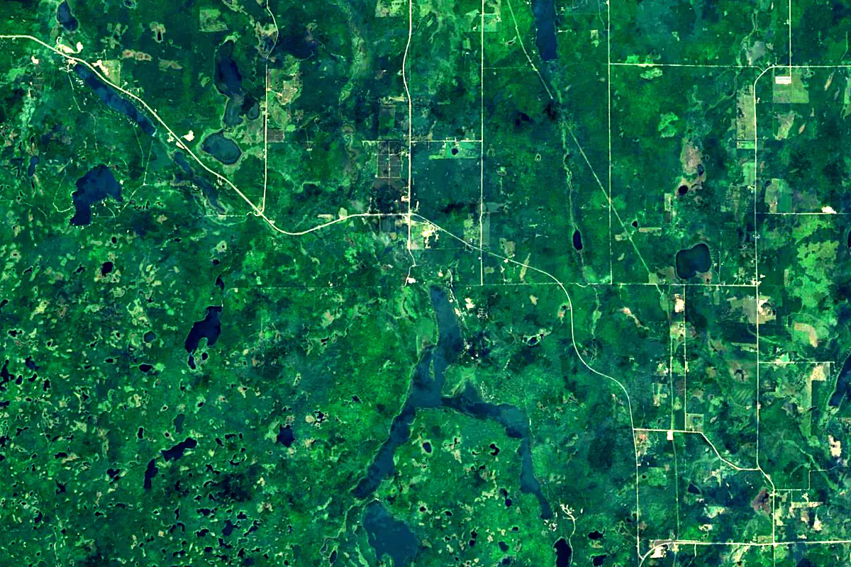
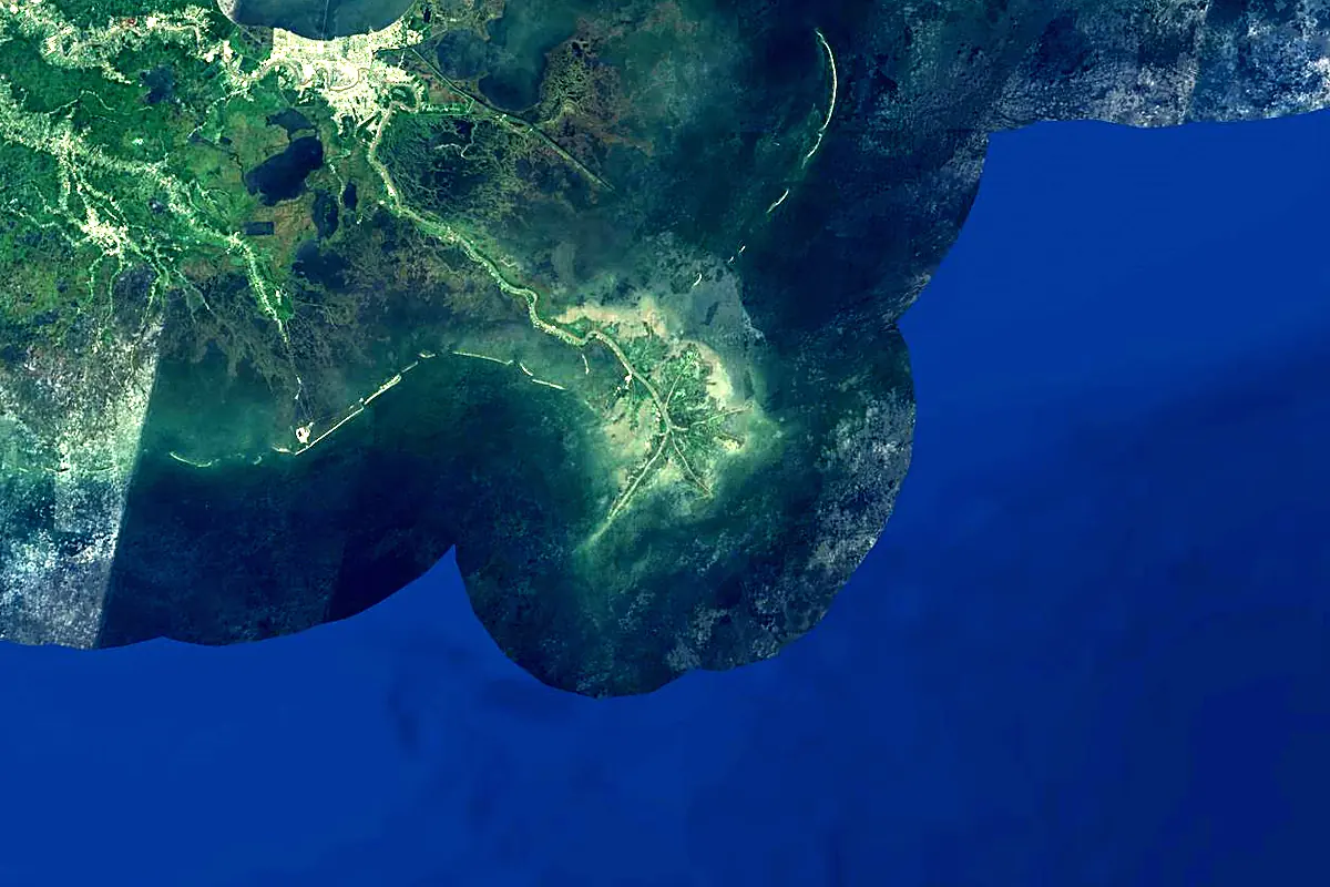
Sentinel-2 cloudless 2016 by EOX IT Services GmbH (contains modified Copernicus Sentinel data 2016), CC BY 4.0. The glowing line is the river as drawn by RiverATLAS.
Photos
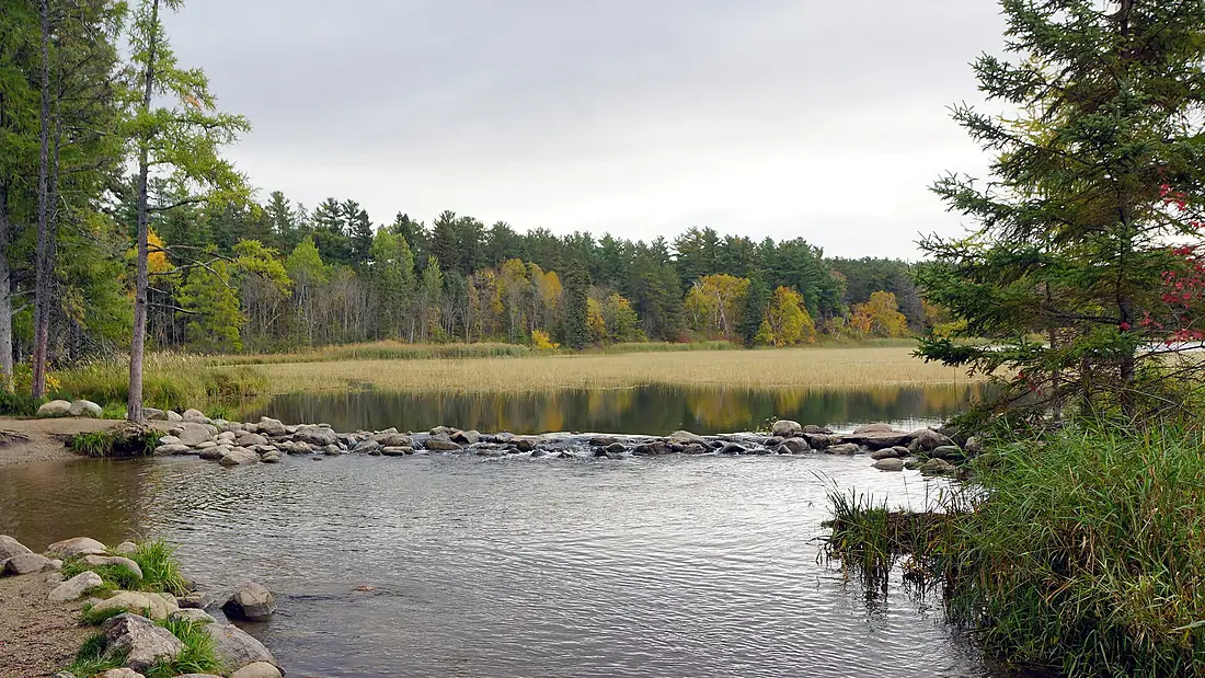
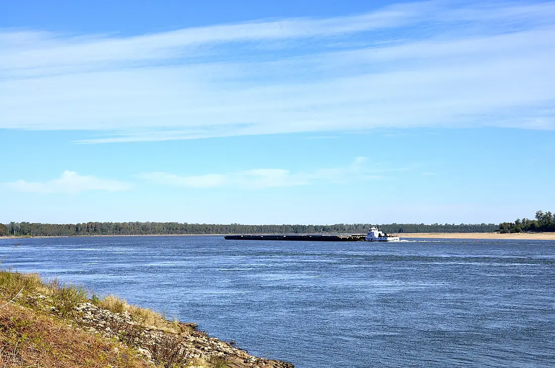
Mississippi River in pictures
Tributaries
Where it flows, and what flows into it
Tributaries (116)
United States3,726 km2,500 m³/sjoins at km 1,575Arkansas RiverUnited States2,364 km240 m³/sjoins at km 2,448Ohio RiverUnited States1,579 km8,000 m³/sjoins at km 1,879White RiverUnited States1,162 km740 m³/sjoins at km 2,418Des Moines RiverUnited States845 km250 m³/sjoins at km 1,318Wisconsin RiverUnited States692 km340 m³/sjoins at km 900St. Francis RiverUnited States686 km400 m³/sjoins at km 2,305Minnesota RiverUnited States534 km120 m³/sjoins at km 581Iowa RiverUnited States520 km280 m³/sjoins at km 1,203Rock RiverUnited States459 km190 m³/sjoins at km 1,133Illinois RiverUnited States432 km660 m³/sjoins at km 1,538Also: Yazoo River, Big Black River, Saint Croix River, Kaskaskia River, Chippewa River, Black River, Wolf River, Apple River, Big Muddy River, Crow Wing River, Maquoketa River, Turkey River, Meramec River, Galena River, Wapsipinicon River, Crow River, Minnehaha Creek, Elk River, Bayou Pierre, Hatchie River, Skunk River, Trempealeau River, Upper Iowa River, Vermillion River
In the same basin
United States1,049 km2,000 m³/sRed RiverUnited States2,189 km1,900 m³/sYellowstone RiverUnited States1,114 km390 m³/sPlatte RiverUnited States500 km200 m³/sCanadian RiverUnited States1,458 km200 m³/sAllegheny RiverUnited States523 km560 m³/sCumberland RiverUnited States1,107 km860 m³/sWabash RiverUnited States960 km1,000 m³/sKansas RiverUnited States238 km210 m³/sCimarron RiverUnited States1,123 km1,100 m³/sNearby
Rivers nearby
United States270 km240 m³/s201 km awayMobile RiverUnited States72 km1,900 m³/s211 km awayAlabama RiverUnited States640 km950 m³/s259 km awayRed RiverUnited States2,189 km1,900 m³/s316 km awayApalachicola RiverUnited States180 km470 m³/s420 km awayChattahoocheeUnited States702 km290 m³/s459 km awaySabine RiverUnited States820 km270 m³/s448 km awayFlint RiverUnited States240 km640 m³/s459 km awayWhere these numbers come from
| Name, length, places | Wikidata (Q1497) · CC0 |
|---|---|
| Course, profile, basin | RiverATLAS v1.0 (HydroATLAS, Linke et al. 2019) · CC BY 4.0 — followed from the source to the mouth given by Wikidata |
| Flow | WaterGAP (RiverATLAS), 1971–2000 · CC BY 4.0 |
| Climate along the river | WorldClim (RiverATLAS), 1970–2000 · CC BY 4.0 |
| Towns, bridges, dams | Wikidata · CC0; GeoNames · CC BY 4.0 |
| Along the river | © OpenStreetMap contributors · ODbL |
| Images | EOX Sentinel-2 cloudless 2016 · CC BY 4.0; Wikimedia Commons |
| Our other atlases | Cascadyas, Lakeyas, Peakyas — Wikidata · CC0; © OpenStreetMap contributors · ODbL; GeoNames · CC BY 4.0; HydroLAKES · CC BY 4.0; NOAA OISST |
Every source and licence is on the data sources page.
The family
Do you prefer beaches, lakes, mountains, waterfalls, islands, rivers or canyons?
Same idea, other landscapes: field atlases built on open data, month by month, in seven languages.
 beaches
 Find your beach: sea temperature, sun and swimming month by month.Visit lakes
 Every lake on Earth: water temperature, ice, depth and the shore.Coming soonVisit mountains
 Every summit in 3D: summit weather, the 0 °C line, huts and trails.Visit waterfalls
 Every waterfall: height, flow month by month and when it roars.Coming soonVisit
  islands
 Every island from the sea up: size, sea temperature, ferries and 3D.Coming soonVisit
  rivers
 Every river from source to sea: the journey, the flow and the basin in numbers.You are here
 canyons
 Every canyon cut to scale: depth to the floor, rim and floor temperatures, trails and viewpoints.Coming soonVisit