River
Ill
217 km from source to mouth · France.
 FranceFlows into Rhine
In numbers
Length
217km
Average flow
54m³/s
Basin
4,760km²
Drop
291m
from 410 m to 119 m
Country
1
The journey
From source to mouth
217 km of river and 68 stops on the way: 64 towns and cities on its banks, dams, bridges and the tributaries that feed it.
- 0 kmSourceat 410 m
- 0 kmDelémont12,682 people
- 2 kmLigsdorf317 people
- 2 kmWinkel301 people
- 2 kmSondersdorf319 people
- 6 kmOltingue695 people
- 6 kmWerentzhouse633 people
- 6 kmFislis396 people
- 6 kmRaedersdorf481 people
- 31 kmAesch10,138 people
- 33 kmDornach6,449 people
- 35 kmArlesheim9,301 people
- 35 kmReinach19,216 people
- 37 kmFahler Wasserfall
- 38 kmMünchenstein11,644 people
- 39 kmMuttenz16,927 people
- 42 kmBirsfelden10,232 people
- 45 kmBinningen14,130 people
- 46 kmBasel177,595 people
- 49 kmSaint-Louis20,871 people
- 51 kmWeil am Rhein32,236 people
- 57 kmEfringen-Kirchen8,235 people
- 66 kmMulhouse104,978 people
- 66 kmBrunstatt-Didenheim8,259 people
- 78 kmIllzach14,923 people
- 79 kmBaldersheim2,596 people
- 79 kmSausheim5,666 people
- 79 kmRuelisheim2,519 people
- 83 kmNeuenburg am Rhein11,682 people
- 98 kmOberhergheim1,315 people
- 98 kmBiltzheim510 people
- 114 kmBreisach am Rhein14,367 people
- 115 kmSainte-Croix-en-Plaine3,004 people
- 115 kmNiederhergheim1,176 people
- 115 kmLogelheim950 people
- 115 kmSundhoffen1,993 people
- 120 kmHorbourg-Wihr6,199 people
- 131 kmIllhaeusern717 people
- 138 kmBaldenheim1,254 people
- 140 kmMuttersholtz2,290 people
- 152 kmEbersheim2,284 people
- 152 kmKogenheim1,172 people
- 152 kmSermersheim955 people
- 152 kmEbersmunster574 people
- 153 kmHuttenheim2,735 people
- 163 kmSchwanau6,858 people
- 164 kmBenfeld5,973 people
- 166 kmSand1,417 people
- 167 kmMatzenheim1,494 people
- 167 kmOsthouse975 people
- 170 kmErstein10,790 people
- 172 kmNordhouse1,753 people
- 177 kmHipsheim1,029 people
- 178 kmFegersheim5,780 people
- 179 kmGeispolsheim7,919 people
- 179 kmEschau5,878 people
- 180 kmAndlautributary
- 180 kmIllkirch-Graffenstaden27,872 people
- 192 kmOstwald13,946 people
- 192 kmBruchetributary
- 192 kmKehl39,584 people
- 192 kmStrasbourg293,771 people
- 194 kmSchiltigheim34,708 people
- 194 kmBischheim18,558 people
- 203 kmLa Wantzenau5,864 people
- 209 kmGambsheim5,312 people
- 210 kmRheinau10,997 people
- 212 kmPeterhafen0.5 km²
- 214 kmOffendorf2,484 people
- 217 kmRhineat 119 m
Water level along the river (RiverATLAS; the height is exaggerated). Towns: GeoNames and Wikidata; bridges, dams and tributaries: Wikidata.
River in Alsace, France
At the mouth it carries 54 m³/s on average: an Olympic pool every 46 seconds. It drops from 410 m to 119 m, 1.3 m per kilometre on average. Its basin covers 4,760 km², about the size of TT. 10.1 million people live in it. Highest water: January and from June to August. Its dams hold back little of its water (4.5% of a year's flow).
Where to start
- StrasbourgLargest city on its banks · 293,771 people
- Strasbourg Airport (SXB)Nearest airport with scheduled flights, 10 km from the cityCar hire at SXB airport (Strasbourg)Discover Cars · Affiliate link↗
- On the water150 ferry piers, marinas, boat rentals and boat ramps along the river (OpenStreetMap)
- Kayak and canoe44 put-ins and rapids mapped (OpenStreetMap)
- From May to SeptemberThe best months to visit
Ill, month by month
Highest water: January and from June to August
Best months to visit: from May to September.
From about 930 m³/s in the lowest month to 1,700 m³/s in the highest. An estimate: the monthly flow is modelled from the lowest and highest months of WaterGAP (RiverATLAS, 1971–2000) and the rain and snow along the river (WorldClim). Dams change the real rhythm. The chip is the average air temperature; below it, the month's rain.
Plan the trip
Plan the trip: boat trips, a bed by the river, a car
Some links above are affiliate links: if you book through them we may earn a commission, at no extra cost to you. It never changes what the data on this page says.
The basin
Ill: the basin in numbers
45,752 km² of land send their water to this river. This is what lives on it.
- 10.1millionpeople live in the basin
- 228/km²people per km²
- 913maverage altitude of the basin
- 1,150mmof rain a year (basin average)
- 6.8°Caverage air temperature
- 12%protected areas
- 2.8%covered by lakes
- 1%glaciers
- 1%permafrost
- 1.7km³held in reservoirs
What covers the basin
- 62% Forest
- 16% Cropland
- 25% Pasture
- 13% Towns and cities
- 1% Ice
RiverATLAS (HydroATLAS v1.0, CC BY 4.0): land cover, people, protected areas, glaciers and dams over the whole basin upstream of the mouth.
Along the river
Ill: what you find on the way
- 156WeirsWasserhaus, Möhlinwehr, Kulturwehr Breisach and 153 more
- 81LocksRhein, Canal de Huningue, Écluse de Kembs and 78 more
- 6WaterfallsWasserfall Laufen, Chlus and 4 more
- 8Rapids
- 36Canoe put-insRheinwehr, Waldschlut, Großmattenrhein and 33 more
- 56Boat rampsGrißheim (km 206,550), Geisswasser, Slipanlage Breisach and 53 more
- 40Ferry piersRhytaxi / Rheintaxi, MuttenzSchifflände, Birschöpfli and 37 more
- 50MarinasMSC Hochrhein, Wassersportclub Grenzach-Wyhlen, IG Rheinhalde and 47 more
- 7River beachesKneip Kaltbad, Plage de Huningue, FKK and 4 more
From OpenStreetMap, within 2.2 km of the river. Not mapped is not the same as not there.
Cross-checked with our atlases
Ill in our other atlases
What our sister atlases know about the waterfalls on this river, the lakes it flows through, the beaches at its mouth, the mountains where it rises and the islands off its mouth.
 1waterfall on the riverCascadyas
 1lake on its wayLakeyas
 8mountains at the sourcePeakyas
Waterfalls (1)
On the river, by Cascadyas
- Fahler Wasserfallkm 33
Cascadyas is coming soonOpen Cascadyas ↗
Lakes and reservoirs (1)
Lakes it flows through, by Lakeyas
- Peterhafenkm 1890.5km²
Lakeyas is coming soonOpen Lakeyas ↗
Mountains at the source (8)
Within 15 km of the source, by Peakyas
- Les Ordons8.6 km away · prominence 214 m995m
- Mont Terri11 km away · prominence 108 m804m
- Montgremay10 km away · prominence 141 m940m
- Mont Russelin12 km away938m
- Roc au Corbeau5.4 km away751m
- Le Morimont5.4 km away749m
- Räschberg13 km away
- Glaser Berg3.8 km away
From space
The source and the mouth, seen from orbit
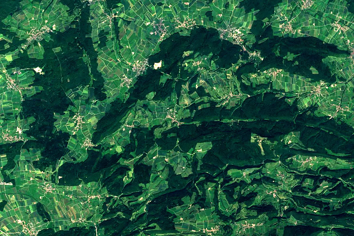
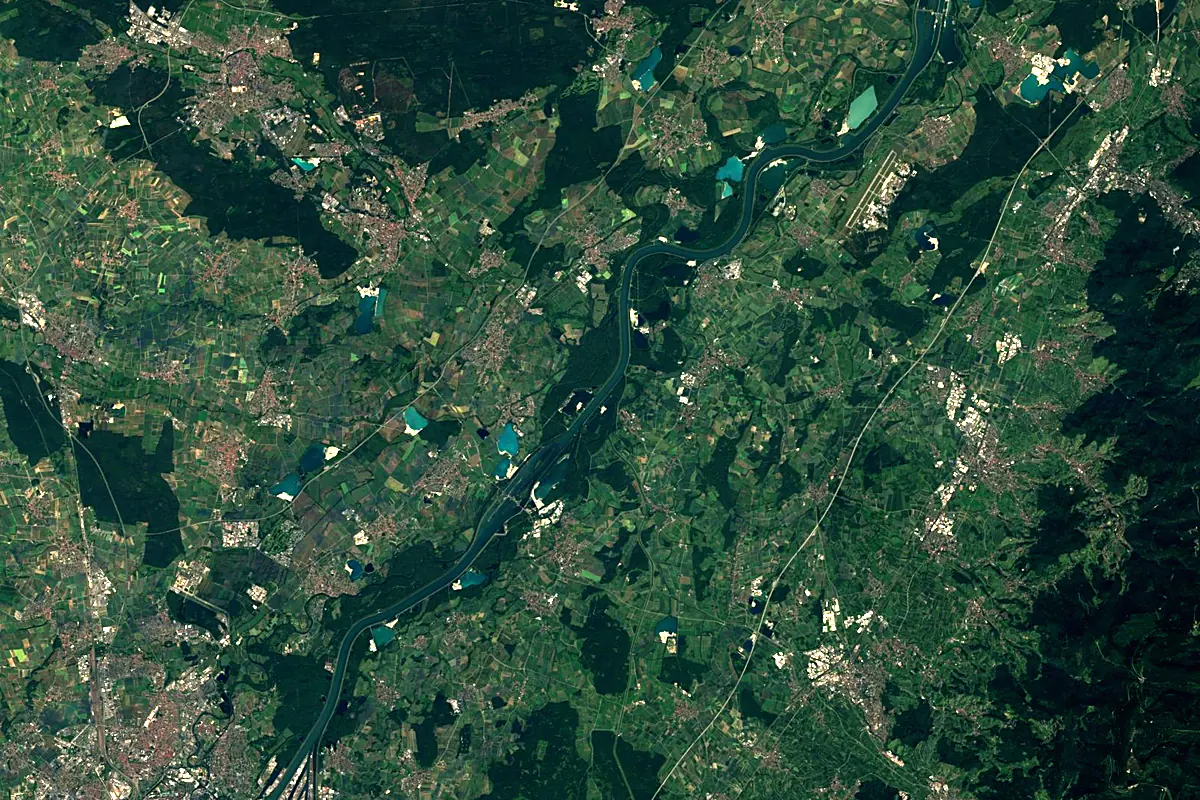
Sentinel-2 cloudless 2016 by EOX IT Services GmbH (contains modified Copernicus Sentinel data 2016), CC BY 4.0. The glowing line is the river as drawn by RiverATLAS.
Photos
Ill in pictures
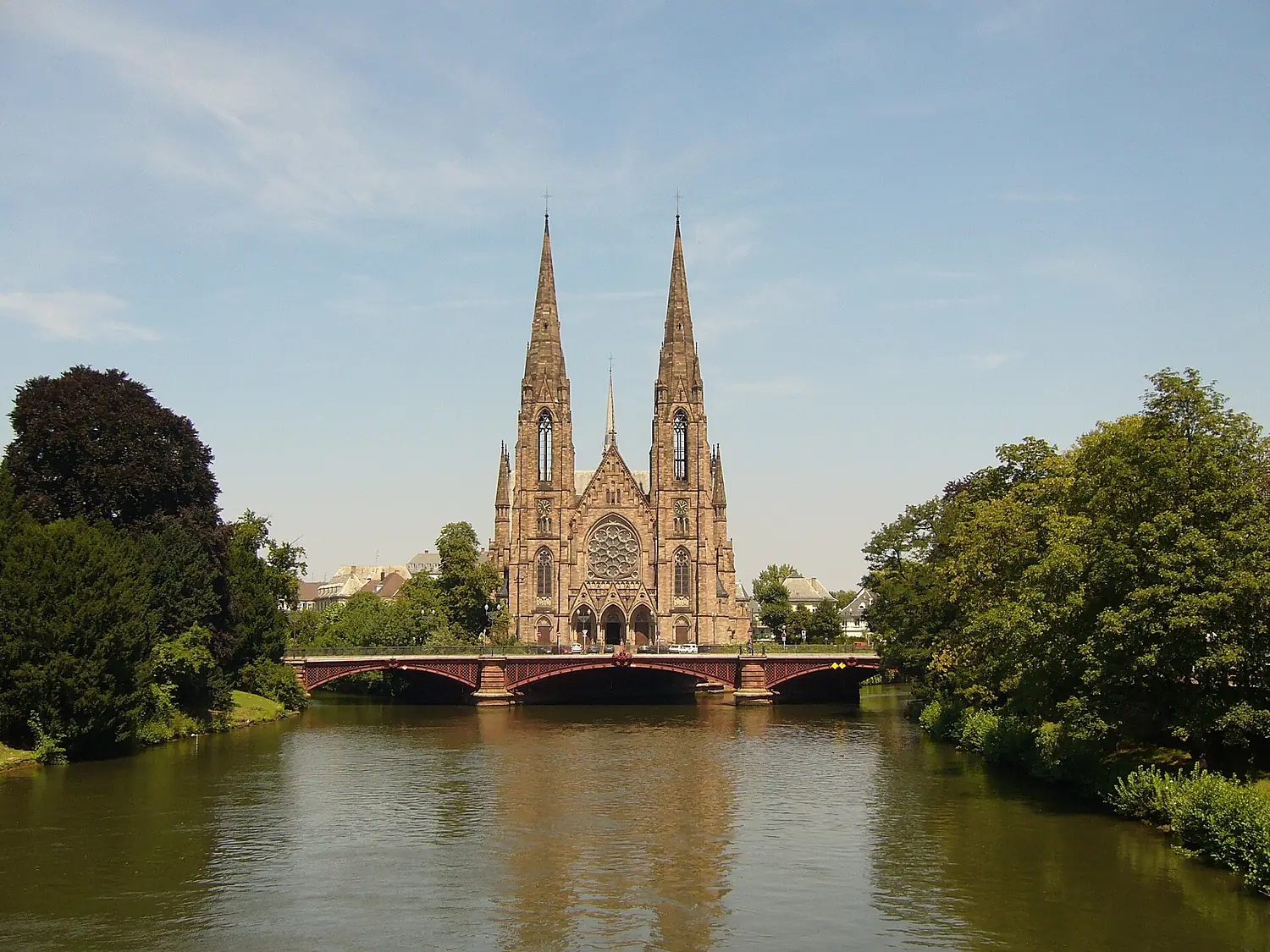
Tributaries
Where it flows, and what flows into it
It flows into
Rhine The Netherlands1,233 km2,200 m³/s
Tributaries (16)
Also: Thur, Bruche, Doller, Fecht, Largue, Lauch, Andlau, Souffel, Dollerbaechlein, Blind (river), Giessen, Quatelbach, Thalbach, Aar, Ehn, Hirtzbach
Nearby
Rivers nearby
 Germany362 km140 m³/s95 km awayAare
 Switzerland295 km560 m³/s124 km awayMainGermany524 km200 m³/s144 km awayBliesFrance100 km19 m³/s79 km awayBregGermany49 km9.7 m³/s95 km awayKocherGermany168 km23 m³/s107 km awayReussSwitzerland159 km130 m³/s136 km awayLimmatSwitzerland140 km100 m³/s136 km away
Where these numbers come from
| Name, length, places | Wikidata (Q668472) · CC0 |
|---|---|
| Course, profile, basin | RiverATLAS v1.0 (HydroATLAS, Linke et al. 2019) · CC BY 4.0 — followed from the source to the mouth given by Wikidata |
| Flow | WaterGAP (RiverATLAS), 1971–2000 · CC BY 4.0 |
| Climate along the river | WorldClim (RiverATLAS), 1970–2000 · CC BY 4.0 |
| Towns, bridges, dams | Wikidata · CC0; GeoNames · CC BY 4.0 |
| Along the river | © OpenStreetMap contributors · ODbL |
| Images | EOX Sentinel-2 cloudless 2016 · CC BY 4.0; Wikimedia Commons |
| Our other atlases | Cascadyas, Lakeyas, Peakyas — Wikidata · CC0; © OpenStreetMap contributors · ODbL; GeoNames · CC BY 4.0; HydroLAKES · CC BY 4.0; NOAA OISST |
Every source and licence is on the data sources page.
The family
Do you prefer beaches, lakes, mountains, waterfalls, islands, rivers or canyons?
Same idea, other landscapes: field atlases built on open data, month by month, in seven languages.
 beaches
 Find your beach: sea temperature, sun and swimming month by month.Visit lakes
 Every lake on Earth: water temperature, ice, depth and the shore.Coming soonVisit mountains
 Every summit in 3D: summit weather, the 0 °C line, huts and trails.Visit waterfalls
 Every waterfall: height, flow month by month and when it roars.Coming soonVisit
  islands
 Every island from the sea up: size, sea temperature, ferries and 3D.Coming soonVisit
  rivers
 Every river from source to sea: the journey, the flow and the basin in numbers.You are here
 canyons
 Every canyon cut to scale: depth to the floor, rim and floor temperatures, trails and viewpoints.Coming soonVisit